Monday, November 29, 2010

Goodbye De Anza and Amado

The cold weather in the last few days has been disappointing.  But yesterdays wind and clouds produced
beautiful sunsets.  Lemonade.  


Bull Springs Road 4 Wheel Trip

Little-used mining road crosses Santa Rita Mountains from Interstate 19 to Hwy. 82 south of Patagonia. See mines along the route and adobe ruins at Alto Camp, once a community of several hundred people. The post office was active until 1933. Narrow, rocky shelf road at higher elevations. Suitable for high clearance stock SUVs. Remote location.

Read more at Trails.com: Bull Springs Road | Arivaca Junction Arizona Off-Road Trails | Trails.com http://www.trails.com/tcatalog_trail.aspx?trailid=XFT002-074#ixzz16duNAxui


Wow!  What a way to spend an afternoon.  Thanks Brooks and Lou! (and Pancho)


Brooks and Lou are staying here in the park and we have been playing golf and enjoying dinners together. They invited us to go on a back road trip with them in their truck which is rigged up for this kind of terrain.  Brooks has a book with maps and descriptions of back road routes in Arizona so we picked one they had not been on, grabbed our picnics and headed out today in cool and windy weather.  We started on Elephant Head road, yes the road that leads to Elephant Rock, one of the prominent landmarks here in the Santa Rita's.  It was paved but then we got to Bull Springs Road and the fun began.

The road was so rough and rocky and full of huge ruts that we were bouncing around like popcorn!  Brooks said the trip was 20 miles and after a few minutes of this I realized we would never get out by dark.  We were going 15 miles an hour max!  But if you do the math we actually had lots of time.  Okay, relax, breathe.  Lou didn't seem to be worried at all.  She just held onto Pancho and enjoyed the ride.  Well so could I!

John was reading from the book and about 2 miles in,  the road was supposed to worsen!  I couldn't imagine this and I think even Brooks was wondering if we should turn back.  Although I couldn't see how we could ever turn around. We gave it another couple of miles and the road actually improved.  Well, it was only as wide as the truck and the bumps and turns were precarious especially as we climbed higher into the mountains but the ruts were not as big.   I guess that is an improvement.

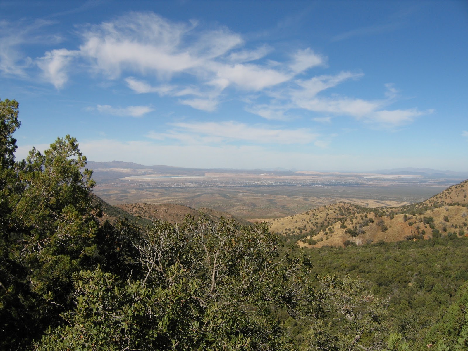
The desert and mountains here are amazing and to be right in the thick of it was a thrill.  Mesquite trees, prickly pear and all kinds of other strange vegetation that I can't name yet is all around.  In between this scrubby vegetation is lots of dust and rocks.  And there are mountains all around...literally.  If you do a 360 that is all you see.  Sometimes we could look down, up or back and see the road, more like track, that we were following.  It looked so small and un-passable for the truck.  But we plodded along and before I knew it we were doing a hairpin turn at an elevation of 5000 feet with no room for error!  Yikes!  My heart pounded a bit but Brooks kept us nicely on track and even stopped so we could get out and take pictures.  What a hero!

I thought heading down would be easier but it was dicey in spots too.  However, by now I realized we were going to live and was really enjoying this.  We did see old mine shafts, junky cars full of bullet holes, other 4-wheelers, deer hunters, cattle and even a couple of campsites.  What?  Are they nuts?  Who would want to tent out in this desert right now, or ever?  It is going down to freezing tonight and who knows who or what is out here?  Deer hunting season must have just started.  We talked to a couple of guys who said they were hunting white-tailed deer.  But we didn't see any deer today.  We did hear gunshots though.


We crossed many cattle guards which are all over Arizona since many areas are free range for cattle.  I do not really understand this since the cattle can't possibly get fat out here eating prickly things and climbing around this rough terrain.  They have to be lean and mean!  But we saw lots of cow patties and even the cows themselves!

We stopped at Alto Camp Ruins for lunch but it was so cold we ate in the truck.  That was just fine however.  Despite the cool temperatures it was a great day to do this trip.  Brooks' truck is very nice and comfortable so we could enjoy the experience and not freeze.  The last part of the trip was through private ranch land but they permit people to go through it.  The road got better and better as we neared highway 82 on the other side.  We did go through a river and there was water in it!  Most of the rivers here have no water right now, they are just dry beds.  Brooks revved it up and we splashed through no problem.

When we got to the highway we turned toward Nogales, the Mexican Border town that is less than half an hour from here by the Interstate.  It took us more than 4 hours to get there by the back route.  What an excellent way to get up close and personal with the desert mountains of Arizona.

Wednesday, November 24, 2010

Kino Springs Golf

Friends we  met in the RV park introduced us to this super scenic golf course near the town of Nogales on the Mexican border 30 minutes south of here.  The course and resort is in need of a face lift but you can see that it was spectacular in its day.  One thing that cannot be changed is the beauty of the area and the challenging golf holes.  Wow!  

The course and clubhouse used to be a ranch (many places used to be a ranch around here) and it has an interesting history.  Makes a great golf course as well!  
"....... His ranch also borders the 5,280-acre Yerba Buena Ranch, once owned by Stewart Granger and his wife, Jean Simmons.  The Grangers hosted frequent guests in their ranch house estate such as John Wayne, who had his own private bungalow built next to the pool, and Elizabeth Taylor. The Granger ranch house now serves as the course’s restaurant and bar, and is loaded with pictures and memorabilia from the Granger era.  Just as the Granger’s did, Kino Springs Golf Club offers guests earnest out-west hospitality. "
 FROM GOLF TODAY, NOVEMBER 9, 2010
Stewart Granger was an actor who played many leading romantic roles and he was married to the actress Jean Simmons at one time. 
After golf we had a drink in the clubhouse and enjoyed the history, gorgeous architecture and pictures of by gone glory days.

Elephant Rock


Elephant Rock
When we were driving home from Kino Springs Golf and got close to home Elephant Rock had taken on a new aspect.  The huge full moon was on it's way up and actually looked like it was sitting on the elephant's trunk for a while.  It was hard to capture this with a small zoom but maybe you get the idea from this.  What an amazing sight!

Bog Springs Hike Madera Canyon

t;After our last hike in Madera Canyon we thought we would try something a little less steep.  So we chose the Bog Springs hike which started lower in the Canyon.  But it was not for wimps either!  It wasn't as steep as the last hike but still lots of climbing and of course more beautiful views.

We did not see a bog but maybe if we were here in monsoon season it would be a different story.


There was a spring at the end of the trail but as with other springs we have seen in the canyon it was tapped and covered with concrete.  

Thursday, November 18, 2010

When the hills are pink....

Each day the sun shines brilliantly and then it sets opposite the Santa Rita Mountains creating this spectacular view.  And then it gets cold.  But that's okay, it's worth it.
 It was only about 5 p.m. when I took this picture and you can see the moon is soon going to be full.
Now, they are really looking pink!  You can see the bulldozers etc. creating more sites in this park.  These are the views from our lounge chairs on our "porch."  One of these days I will get a good picture of "Elephant Rock", one of my favourites around here.

Mines and Missiles

What an amazing day of mines and missiles!  John had been threatening me with this since we got to AZ and today was the day; a testosterone day.  Of course as you know we ALL have testosterone so even I was interested once I got there.


The humungous copper pit mines are evident from Tuscon to Tubac and we have been curious about it, about it's impact and history.  We went on a tour today starting at the Asarco Mineral Discovery Centre, travelling to the rim of the pit and walking into a viewing area of the process.  It was complicated but I learned lots and really enjoyed it!


One of the best parts was learning about the impact on the environment.  We had visions of tailing ponds spilling out and destroying Green Valley!  Remember Hungary?  Well I feel reassured.  I was amazed at the re-habilitation of the land that is going on when a mine runs out.  Cattle are involved for heaven's sake!  That explains a lot!  Herds are brought in when a tailing pond is being re-vitalized.  Their hooves help to break up hay and disperse seeds and aerate the soil, their pies fertilize and they actually kick start the growing of grasses and natural desert vegetation  in a depleted area.


There was an amazing cactus garden outside the visitor centre.  As the tailing ponds expand the natural vegetation is moved and I know this garden is one result.  Another benefit is the lining of Arizona roads with this vegetation removed carefully by landscapers.  The relationship of mining to Arizona has gone on for a long time and we have seen evidence of it everywhere.  Now we have a better understanding of this mutually beneficial relationship.  Employment and prosperity for people of Arizona is hard to deny.  Of course we got the "party line" today.  I am sure there is another side.


After the Asarco Mine Tour we drove down the road to the Titan 2 Missile Museum. GRRRRR! This was the largest missile ever built in the U.S. and at the height of the cold war there were multiple Titan sites in Kansas, Arkansas and Arizona. The reason for the concentration of missiles in these areas is "classified". Ha! Likely having to do with the politicians in power in those states at the time and perhaps the lack of population density? Expendables? Okay, I will try not to be cynical. MAD!! (Mutual Assured Destruction) All the Titan sites have been destroyed except this one. It is now a museum run mostly by volunteers. And it is a well preserved site. Going down to the control room and viewing this impressive missile in it's silo was fascinating. I think John thought he was back at work!


 I gave John the camera since I figured he would know what was important to photograph but he was so busy listening and imagining working down here that he didn't take any pictures!  The rattlesnake signs were real.

Apparently snakes would surprise the 4 workers who manned the site on 24 hour shifts as they entered different areas.


The buildings, even underground were on springs to withstand any seismic action that may occur.  That may also be a reason why sites were placed here...not much seismic action.  It reminded me of a submarine.  How would I know this?  I have toured an old sub in Pittsburgh.

Wednesday, November 17, 2010

Mine Vault Trail to Agua Caliente Saddle

Another gorgeous day at Madera Canyon.  From our RV we look at the beautiful Santa Rita Mountains. We are getting to know the names of some of the peaks.  Mt. Wrightson is the highest point around here.  Elephant Rock is one of the most interesting from all angles but I haven't been able to get a good picture of it.  These peaks and canyons look almost surreal from the Valley.  And from the peaks and canyons the Valley looks surreal.
Sycamore changing colour
This hike was very steep and we didn't actually get as far as we had hoped.  Once we reached the sign to the saddle we realized we had a long way to walk down!  And it took longer to go down than to go up.  Baby steps!  We had sore legs for a couple of days after this.
Wrightson Peak

Valley View


 The sky is sooooooooooo blue here and so clear when up in Madera Canyon.
Evidence of the mine.

Yodelly yo ho ho!

Tubac Cemetery

 This beautiful Cemetery was interesting to walk around.  The gorgeous flowers, toys, balloons and even beer cans have been left by the living to pay special tribute to their loved ones.  Our cemeteries at home look awfully plain and dull in comparison. Look closely at the sign.  That is not how you spell cemetery in Spanish so I am not sure what happened!
 This lucky fellow has someone coming to drink beer with him.  And they leave the empties!
Some graves were simple stone piles, some were ornate tiles or slabs but all had wreathes and momentos celebrating the life of the deceased.

Tubac Presidio

Back to school!  We toured the Presidio Ruins and Museum at historical Tubac.  The Presidio is a fort which was established by the Spanish in 1752.  Currently most of it is in ruins but the site has been excavated and you can see foundations below ground.  It also contains the school house which was built there in the 1800's and a museum which has an extensive history of the area and it's diverse people.
 John helped this tall teacher to try to drill something into my head.  This one room school house was pretty much the same as the ones we attended in Ontario except for the outside which was covered in stucco instead of wood or bricks.
These lovely ladies had an amazing array of old and new world foods used in this area historically.  The smaller lady was incredibly knowledgeable about the plants, crops, history and food preparation techniques of the natives and then the Spanish as they came together in the New World.  She's from Kentucky originally but her Spanish was excellent and she had obviously lived here for years and studied the history.  We even got to taste some of the food and they had made delicious baked tortillas with cinnamon and sugar on them using an old recipe.  We asked if we could take their picture and the one who had done most of the talking said; "let me take my glasses off, I want to look sexy!"
 The Tubac Presidio was in danger of being shut down when huge cuts were made to State Parks in the last few years.  It is now run by volunteers as are many of the threatened State Parks.  A State Park does not necessarily mean a place to camp.  It is often a monument or museum with historical significance so thank goodness for the volunteers.

Wednesday, November 10, 2010

"Tin Cup" Tubac Golf Resort

Imagine how thrilled we were to find out we were next door to the Golf Course where Kevin Costner shot a ball through the bar and emptied his bag of golf balls into a pond!  Well I was thrilled about the Kevin Costner part and John was thrilled to play the course.  Of course he does like Rene Russeau.


John and I both parred the famous hole.  The pond is not as big as it looked on screen but the golf course is just as beautiful.  Parring the 2nd hardest hole made us proud.   I won't talk about the rest of my game.  The company was good; we met a couple who are  building a house in Tubac and they are staying in an RV in the meantime next to us here at de Anza Trails.


Tubac Golf Resort is on the grounds of an historical ranch and I think some of the buildings are original to the ranch.  We were pretty surprised to see cattle grazing on the fairway of the 9th hole of one of the nines!


Actually, when we finished the "Rancho" nine one cattle beast was in the bunker and had to be corralled by one of the starters.  Despite cattle guards this beast had gotten into the wrong area.  I am surprised though to see the cattle on the course.  It is pretty unique and maintains the historic ranch flavour.  I could hardly putt I was so distracted by the fellow trying to chase a heiffer away from the green.  By the way, this is not a "cow pasture" course at all!

The course was beautiful.  I know you are sick of hearing it but the mountain views were amazing.  I am getting used to "Elephant Rock" and have now seen it from all angles.  I will really miss it when we leave here.


There were many mesquite trees but they looked different from others we have seen.  I think they were older.  They branch out in a way similar to live oaks we have seen in Georgia and Florida but are shorter.  Our playing partner from Texas said they cut them down for fire wood but here she was amused to see people used them for landscaping.  Different strokes.


The course was tough!  The last 3 holes of Rancho are called the "Tubac Triangle."  A charity tournament was played here in the last couple of days and the pin placements were unreal.  The tees were also back as far as they could go.  We got our money's worth!
Strange!  Now I can't turn this around! 

We have played 3 courses around here so far and they are all great.  Canoa Ranch GC at Green Valley (10 miles north of here) was what I would call a "desert" course where you have to hit the green target over the desert.  The mountain views in the background are....well you know!

About Me

My photo
Home is where you are.